We explore tsunamis, and explain their characteristics, causes and effects. In addition, we discuss megathrust earthquakes.
What is a tsunami?
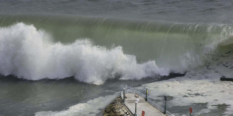
A tsunami, also called a seismic sea wave, is a series of waves traveling through the ocean at high speeds. Upon reaching the coast, they can rise to heights of up to 100 feet (30 m).
Tsunamis occur in large bodies of water such as seas and oceans, and are extremely rare in smaller bodies of water like lakes and lagoons.
They are caused by earthquakes occurring in the oceanic crust, which release large amounts of energy. This energy is transferred to the water, generating waves that travel through the ocean.
Tsunamis mainly occur in the Pacific Ocean, and are less frequent in the Indian and Atlantic Oceans.
- See also: Flood
Causes of tsunamis
Most tsunamis are caused by earthquakes occurring on the seafloor. Undersea earthquakes cause a sudden movement of the tectonic plates that make up the ocean floor, releasing large amounts of energy. This energy is transferred to the water through waves and may result in the formation of a tsunami.
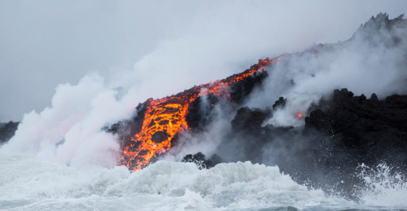
Less frequently, tsunamis may be caused by eruptions of underwater volcanoes. These eruptions release a considerable amount of energy, which propagates through the water and can form large waves.
Another possible yet rarer cause is the impact of a meteorite in the ocean, which can also produce waves that propagate through ocean water.
Effects of tsunamis
The most common effects of tsunamis are:
- Flooding, caused by the impact of a tsunami on coastal areas.
- Loss of human life and property as a result of the impact of waves on the coastline, flooding, or rip currents that propel people and objects into the sea.
- Contamination of freshwater by saltwater penetrating inland. This not only affects the availability of drinking water but it also significantly alters soil salinity, which may negatively impact its fertility.
- Degradation or destruction of nearshore submarine ecosystems. The impact of waves may jeopardize the balance of coastal ecosystems and may have a significant impact on the life development of corals, algae, and other marine species.
How are tsunamis measured?
Tsunamis can be measured in:
- Height. Refers to the vertical height of the waves when reaching the coast.
- Wavelength. Measures the distance between two successive wave crests. The wavelength of a tsunami can be very long, meaning the distance between two wave crests may span several hundred miles.
- Front length. Refers to the width of the waves produced by the tsunami.
How to prepare from a tsunami
Several protective measures can be taken to prevent or mitigate the impact of tsunamis in coastal areas:
- Early warning systems. They allow coastal communities to evacuate or be prepared for the arrival of a tsunami.
- Evacuation plans. They help people know what to do in the event of a tsunami warning. In areas frequently affected by these natural phenomena, there are safety shelters where people can take refuge from the large waves.
- Tsunami-resistant infrastructure. Breakwaters and protective barriers help reduce the impact of incoming waves upon reaching the mainland.
Warning systems
Since the 1920s, warning systems have been in place to prevent tsunamis in areas where tectonic movement is frequent.
In 1949, the "Pacific Tsunami Warning Center" was established in the United States. It is one of the major tsunami warning systems in the world, covering most of the Pacific Ocean.
A prevention system called CREST (Consolidated Reporting of Earthquakes and Seaquakes) is used on the northwest coast of the United States and in Hawaii. It is a tsunami warning system using ocean seismic sensors, developed by the U.S. Geological Survey.
Likewise, tsunami warning systems exist in other parts of the world, such as the Indian Ocean Tsunami Warning and Mitigation System based in Australia, and the Pacific Tsunami Warning System, which watches the coastlines of countries including Chile, Peru and New Zealand.
Tsunami hazard
The movement of oceanic plates is the most frequent cause of tsunamis. How dangerous a tsunami will be when reaching the coastline depends on several factors:
- Magnitude of the earthquake. The higher the magnitude of the earthquake, the more energy is released through the oceanic crust, and the more energy is transferred through the ocean water.
- Hypocenter depth. The hypocenter is the point beneath the Earth's crust where the tectonic movement originates. At greater depths, the chances of a destructive tsunami are lower, as much of the energy released dissipates before reaching the water.
- Seafloor morphology. The presence of submarine canyons, volcanoes, or continental shelves can amplify or diminish the force of a tsunami.
- Distance from the epicenter. The epicenter is the point on the water surface directly above the hypocenter. Tsunamis lose strength as they move away from the epicenter, so the greater the distance from the coast, the lesser their impact.
Megathrust earthquakes
Megathrust earthquakes are high-magnitude underwater earthquakes that can generate highly destructive tsunamis. To be considered a megathrust earthquake, the seismic event must register a magnitude of 9.0 or higher on the Richter scale.
Megathrust earthquakes are extremely rare events and do not occur frequently. However, due to their great destructive power, they are the object of constant study and research by geologists and specialists.
Differences with storm surges and tidal bores
What is a storm surge?
A storm surge is a rise in seawater level due to weather conditions such as storms, hurricanes, or cyclones.
- Storm surges can be very destructive if combined with heavy rain and high winds.
- The key difference with tsunamis is that surges consist of surface waves, with their origin being wind, not tectonic activity.
What is a tidal bore?
A tidal bore is a particular type of tide. It is a natural oceanic phenomenon that makes reference to a long, regular tidal wave traveling through the oceans.
It is produced by the interaction between gravity, the Earth's rotation movement, and tidal forces. It is characterized by waves of great length and low height, which do not have a significant impact on coastlines.
- Tidal bores differ from storm surges in that they are not caused by meteorological conditions.
- Tidal bores differ from tsunamis in that they are not caused by tectonic activity.
Worst tsunamis in history
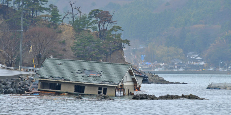
2011 Japan Tsunami
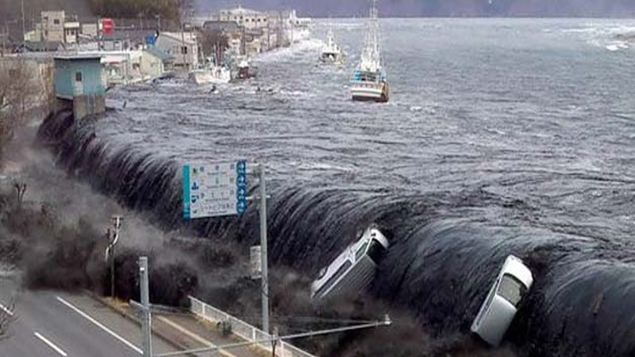
The Japan tsunami, officially called the “Great East Japan Earthquake” and also known as the Tohoku earthquake, occurred on March 11, 2011 off the coast of Japan. The earthquake that generated the tsunami had a magnitude of 9.0 on the Richter scale.
The waves reached heights of 130 feet (40 m), causing the death of over 15,000 people. It was highly destructive, partly because the epicenter was located at a very close distance from the coastline.
The effects of this tsunami extended to the United States, to coastal areas in California and Hawaii, where the waves exceeded 10 feet (3 m) in height, and traveled 2 miles (3 km) inland. This earthquake, which lasted 6 minutes, was the most powerful ever experienced in Japan and the fourth largest in the world.
2004 Indian Ocean Tsunami
The Indian Ocean tsunami occurred on December 26, 2004 off the coast of Sumatra, Indonesia, following an undersea earthquake of 9.1 on the Richter scale.
It affected several countries in the Indian Ocean including Indonesia, Thailand, Sri Lanka, India, and Somalia. An estimated 230,000 people died, with millions being affected otherwise. The tsunami caused massive damage to coastal infrastructure, destroying entire cities, ports, and fishing communities. Rescue and recovery efforts continued for months.
References
- López Bermúdez, F. (2002). Geografía Física y conservación de la naturaleza. Papeles de Geografía, 36. https://www.researchgate.net/
- Pech, P y Regnauld, H. (1997). Geografía Física. Docencia.
- Tarbuck, E. y Lutgens, F. (1999). Ciencias de la Tierra. Una introducción a la geología física. Prentice Hall.
Explore next:
Was this information useful to you?
Yes NoThank you for visiting us :)